What Is ADS-B? How Flight Tracking Actually Works
There’s a jet crossing your window right now, and it is telling you exactly who it is. Not to you specifically — it’s shouting the same thing at everyone in radio range, twice a second, in the clear, whether or not anybody is listening. Its identity, its position, how high it is, how fast it’s going, and which way it’s pointed.
That broadcast is called ADS-B, and once you know how it works, the sky stops being anonymous.
The name, unpacked
Automatic Dependent Surveillance — Broadcast. Four words doing real work:
- Automatic — nobody presses a button. The transponder transmits on its own, continuously, from before pushback until after landing.
- Dependent — this is the interesting one. The aircraft is reporting a position it worked out itself, from satellite navigation. The ground isn’t measuring it; the ground is being told.
- Surveillance — the purpose: keeping track of where aircraft are.
- Broadcast — sent to everyone at once. No handshake, no request, no addressee.
Compare that to classic radar, which is independent: a ground station throws energy at the sky and measures what bounces back. Radar doesn’t care what an aircraft claims. It’s also expensive, mechanically enormous, refreshes only as fast as the dish sweeps, and has real trouble at low altitude and long range.
ADS-B flips the arrangement. The aircraft already knows precisely where it is — it has GPS — so instead of being hunted, it simply announces. The result updates about once a second instead of once every several seconds, is accurate to a handful of meters, and needs a receiving antenna roughly the size of a pencil.
The tradeoff is right there in the word dependent: the system trusts the aircraft’s own report. That’s why ADS-B supplements radar rather than replacing it outright in controlled airspace.
What’s actually in the signal
Most airliners broadcast ADS-B Out on 1090 MHz, in short bursts a few hundred microseconds long. Different message types carry different pieces, and a receiver assembles them into one picture over a few seconds:
- The ICAO address — a unique 24-bit hex identifier burned into that specific airframe. Think of it as the aircraft’s permanent serial number.
A1B2C3. - The callsign — the flight identity for this trip:
AAL415,SWA88,N512JT. The same airframe flies under a different callsign tomorrow. - Position — latitude and longitude, from the aircraft’s navigation system.
- Altitude — usually barometric, sometimes geometric, occasionally both.
- Velocity — ground speed, vertical rate (climbing or descending, in feet per minute), and track.
- Status bits — whether the aircraft is airborne or on the ground, plus a measure of how much its own navigation system trusts the position it’s reporting.
Note what is not in there: passengers, cargo, destination, or anything the airline would consider private. It’s a position report, which is the entire point.
Heading, track, and the wind
A small thing that trips people up on any radar display: the little arrow on the screen usually shows track, not heading.
Heading is where the nose is pointed. Track is where the aircraft is actually going over the ground. In a strong crosswind those differ — sometimes by ten or fifteen degrees — because the aircraft is flying slightly sideways into the wind to hold a straight line. If a blip looks like it’s crabbing across the display, that’s not a glitch. That’s a jet stream.
The same wind explains why ground speed on a tracker can read 380 mph westbound and 620 mph eastbound for the same aircraft type. Through the air they’re doing the same speed. Over your house, they are very much not.
Why the altitude colors
Every controller’s scope and nearly every hobbyist display colors aircraft by altitude, and it isn’t decoration. Altitude is the fastest way to sort a cluttered sky into stories:
- On the ground — taxiing, or just lifting off. Slow, close, and going somewhere in the next five minutes.
- Low, a few thousand feet — approach and departure traffic. If you live under a corridor, these are the ones you hear.
- Middle altitudes — climbing out or stepping down, usually within a hundred miles of an airport that matters to them.
- Cruise, above 30,000 feet — overflights. They took off somewhere far away and they are not stopping here.
Once the colors mean something, a glance tells you whether the sky above you is arriving or merely passing through.
Do you need your own receiver?
Only if you want to pick up the signal yourself. A receiver is a small radio and antenna that listens on 1090 MHz, where most airliners broadcast, and thousands of hobbyists run them. Squawk Box does not need one: it gets live ADS-B positions over your home WiFi, relayed through my servers and partly sourced from adsb.lol, a community network of volunteer receivers, so there is no antenna or dongle. The catch is coverage. It depends on those volunteers, so it is strongest around cities and major airports and can be thinner somewhere very remote.
The open-source Micro Radar build skips the antenna too: its parts list has no receiver, and its README says it gets flight data from the OpenSky Network’s API. If you are weighing a few options side by side, How to Choose a Desktop Flight Tracker compares them.
What you won’t see
A tracker is honest only if it’s honest about its gaps.
Aircraft without ADS-B Out. In US airspace the equipment mandate covers most controlled airspace, but not all flying happens there. Gliders, balloons, ultralights, and some vintage aircraft operating outside those areas legitimately fly without it.
Aircraft that are deliberately masked. There are privacy programs that let an operator’s identity be swapped or suppressed before data reaches public feeds. Military aircraft can be absent when they do not broadcast, and the ones that do appear are drawn in silver on Squawk Box.
Aircraft below your horizon. 1090 MHz is line-of-sight. A receiver on a desk hears an airliner at 35,000 feet from well over a hundred miles away, and may completely miss a helicopter at 800 feet six miles out because a ridge is in the way. Coverage isn’t a circle; it’s a lumpy dome shaped by whatever’s between you and the sky.
The last few seconds. Aggregated feeds add a little latency, and a display refreshing every couple of minutes shows you a sky that’s a couple of minutes old. Fine for curiosity, useless for anything operational — which is why nothing built on this data should ever be used for actual flight following or separation.
Reading a scope like a controller
Put it together and a radar view becomes readable at a glance:
- Range rings tell you distance. The center is you.
- Color tells you the phase of flight.
- The vector line off each aircraft shows where it’s going and, by its length, roughly how fast.
- Clusters along a line mean you’ve found an airway — the invisible highway aircraft actually follow, which is why the same three-mile-wide strip of your sky sees a plane every four minutes while the rest is empty.
- A blip that slows, descends, and turns onto a consistent final heading is landing somewhere within about twenty miles.
That last one is the small pleasure of watching your own airspace over time: you stop seeing individual planes and start seeing the pattern — the morning departure bank, the evening arrival push, the cargo flights that own 3 a.m., and the one regional turboprop that takes the same shortcut over your roof every single weekday.
You knew the planes were up there. ADS-B is the part where they introduce themselves.
QUICK ANSWERS
Fair questions
What does ADS-B stand for?
ADS-B stands for Automatic Dependent Surveillance-Broadcast. It is the signal an aircraft sends on its own, about twice a second, with its identity, position, altitude and speed, to anyone with a receiver.
Do I need a receiver to track planes at home?
No, not unless you want to pick up the radio signal yourself. A receiver is a small radio and antenna that listens on 1090 MHz, where most airliners broadcast. Squawk Box gets live ADS-B positions over your home WiFi instead, relayed through my servers and partly sourced from adsb.lol, a community network of volunteer receivers, so there is no antenna or dongle. Coverage depends on those volunteers and is strongest around cities and major airports.
Is tracking planes legal?
Yes. ADS-B is an unencrypted broadcast that aircraft transmit deliberately, in the open, on a public radio frequency. Anyone with a receiver is allowed to listen, and thousands of hobbyists do. What’s regulated is transmitting, not receiving. The data is also published by the FAA and other authorities, which is why flight-tracking websites exist and why nobody has to sneak around to build one.
Why do some planes not show up?
Three common reasons. Some aircraft aren’t required to carry ADS-B Out at all: gliders, balloons, and older aircraft flying outside controlled airspace. Some owners are enrolled in privacy programs that mask or swap the identifier before the data reaches the public. And some are simply out of radio range: 1090 MHz is line-of-sight, so a hill, a building, or the curve of the Earth can hide a low-flying aircraft that’s technically nearby.
What is a squawk code?
A four-digit number, each digit 0–7, that air traffic control assigns to a flight so its blip can be told apart from every other blip. Most are routine and forgettable, but a few are universal: 7500 means hijacking, 7600 means radio failure, and 7700 means a general emergency. Pilots learn them as ‘seven-five, taken alive; seven-six, radio fix; seven-seven, going to heaven,’ which is grim and effective.
Why doesn’t the altitude match what the pilot announces?
Because they’re two different measurements. ADS-B usually reports barometric altitude (pressure converted to feet against a standard sea-level setting), while the aircraft’s GPS reports geometric altitude, its actual height above the ellipsoid. Above the transition altitude everyone deliberately flies on the standard pressure setting so that aircraft stay correctly separated from each other, even when all of them are a few hundred feet off from the true number.
THE GADGET FOR THIS OBSESSION
Put it on your desk
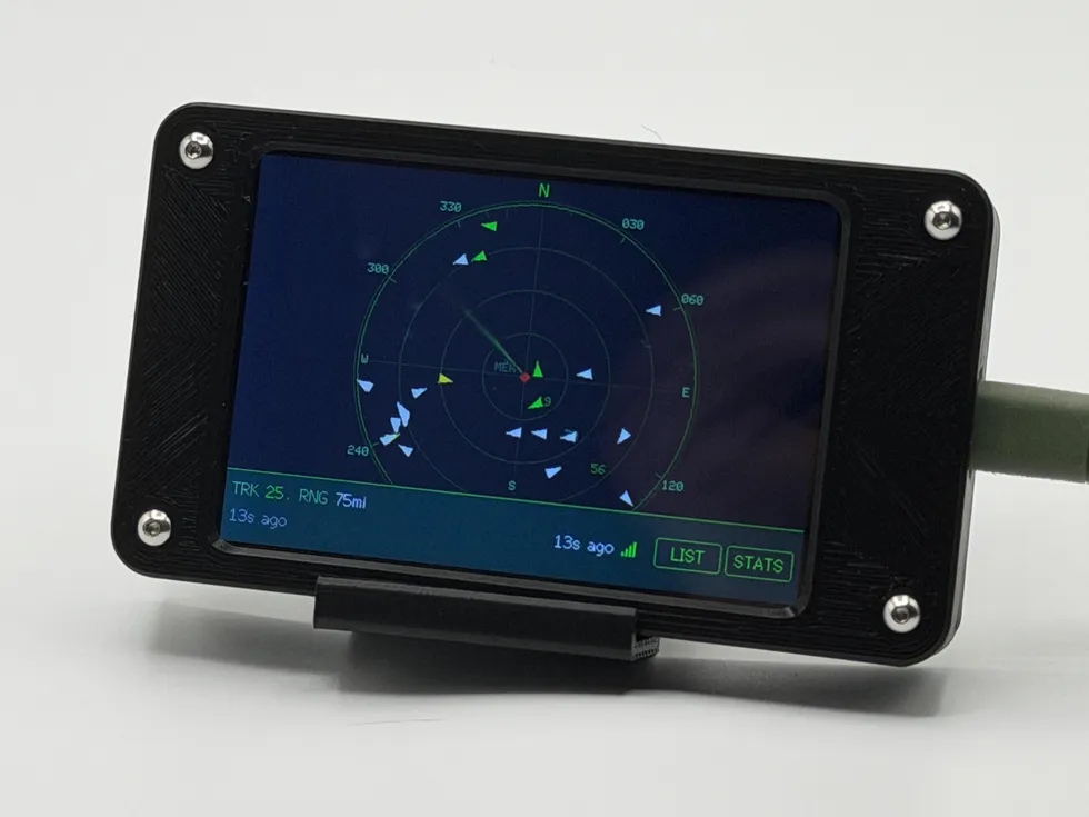
Squawk Box also headlines the gift guide for pilots, plane spotters & aviation nerds, if you happen to be shopping for one.
MORE LAB NOTES
- How to Choose a Desktop Flight Tracker: 5 Questions to Ask
- Magnitude vs. Intensity: The Two Numbers Every Earthquake Gets
- What Is a Starlink Train? The String of Lights, Explained
- Weather Watch vs. Warning vs. Advisory: The Severity Ladder
- The Board Inside Every PlankLabs Gadget
- The Printers Behind the Shells: a Flashforge AD5X and a Bambu Lab X2D
- Arduino: The Workbench My Firmware Is Built On
- How the Outdoor Score Works: One Honest Number for “Should I Be Outside?”
- How to Read a Tide Chart (and Why Old Tide Clocks Drift)
- When Can You Actually See the ISS? Visibility Windows, Explained
- Is It Your WiFi or Your ISP? How to Tell in 60 Seconds